
How to Find Your Property Lines
The short answer is that there are several ways to locate your property lines, ranging from free online tools to a professional land survey. Free methods can give you a general idea of where your boundaries are. Only a licensed land surveyor can give you a legally binding answer.
Why Knowing Your Property Lines Matters
Before you build a fence, add a structure, or resolve a disagreement with a neighbor, you need to know exactly where your property ends and the next one begins. Guessing or estimating can lead to costly mistakes, including fines, forced removal of structures, and legal disputes that take months to resolve.
In Auburn and throughout Lee County, property line questions come up most often in these situations:
- Planning a fence installation
- Starting a home addition or outbuilding project
- Resolving a boundary dispute with a neighbor
- Purchasing land or a home
- Applying for a building permit
Step 1: Check Your Property Deed
Your deed is the legal document that describes the boundaries of your property. It is the first place to look when trying to understand your property lines.
Most deeds include a written legal description of the property. This description may use a lot and block number if the property is in a recorded subdivision, or it may use a metes-and-bounds description that lists specific distances and directions around the perimeter of the land.
You can get a copy of your deed at the Lee County Probate Court in Opelika. The probate court records all deeds, plats, and other land documents for every city and community in Lee County, including Auburn. Most offices are open weekdays from 8:00 AM to 4:30 PM. Bring the property address or the owner name to make searching easier.
Step 2: Search Lee County GIS and Property Maps
Lee County provides a public GIS mapping system that shows parcel boundaries, ownership information, and tax maps for properties throughout the county. You can access it at alabamagis.com/Lee.
The City of Auburn also maintains its own interactive map at auburnalabama.org/maps. This map includes parcel data, property information, zoning layers, and aerial photography going back several decades. It is a useful starting point for getting a visual overview of your lot and its approximate boundaries.
These tools are free and available online. They are helpful for getting a general picture of your property, but they are not precise enough to use for construction, fencing, or resolving a legal boundary dispute. GIS maps can be off by several feet and do not replace a professional survey.
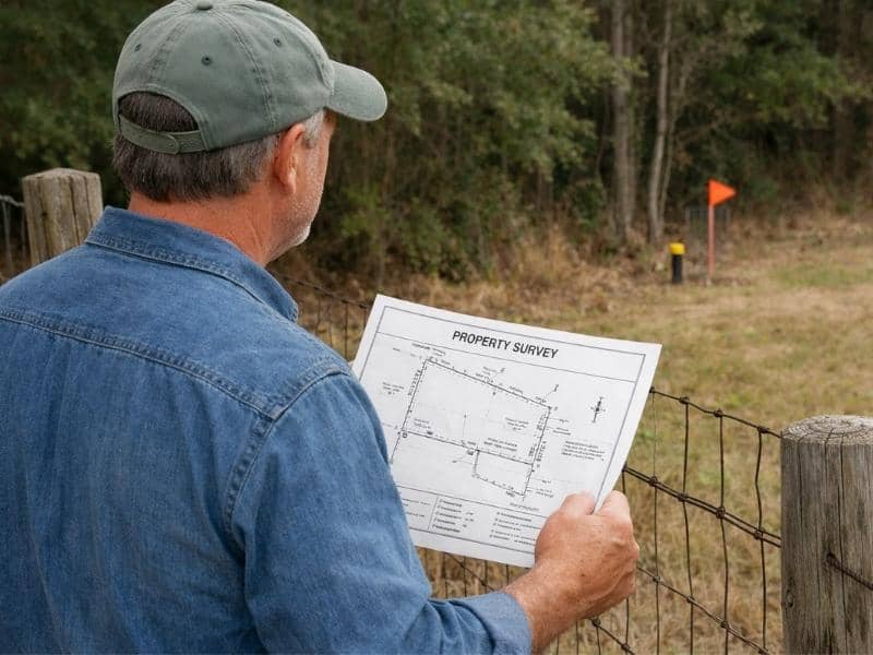
Step 3: Look for Existing Survey Markers
If a licensed surveyor has previously worked on your property, physical markers may already be in place. These are typically iron pins, rebar stakes, or concrete monuments placed at the corners of the property.
Look for these markers at the corners of your lot, often near the edge of the road, along fence lines, or at the rear corners of the property. They may be flush with the ground or just slightly above it, and they can be easy to miss if grass or soil has grown over them.
If you find markers, do not assume they are current or accurate without verification. Markers can be moved accidentally during construction or landscaping. A surveyor can confirm whether the existing markers match the deed description.
Step 4: Review a Prior Survey
If a survey has already been done on your property, a copy may be on file with the Lee County Probate Court, your title company, or your mortgage lender. Prior surveys are sometimes included in the closing documents you received when you purchased the property.
A prior survey can tell you the dimensions of your lot, the location of corners, and any easements or encroachments that were identified at the time of the survey. Keep in mind that conditions can change over time. If the prior survey is old, or if construction or landscaping has happened since then, a new survey may be needed.
Step 5: Hire a Licensed Land Surveyor

If you need a legally accurate answer about where your property lines are, a licensed Professional Land Surveyor is the only person who can provide one. In Alabama, only a licensed surveyor can legally establish property boundaries and set permanent corner markers.
A professional boundary survey costs between $500 and $1,500 for a standard residential lot. The surveyor will research deed records at the probate court, locate existing monuments, run measurements across the property, and set or confirm corner markers. The result is a legally defensible document that you can use for permitting, construction, real estate transactions, and boundary disputes.
If you have already read about survey costs, you know that the price depends on property size, terrain, and the availability of existing records. The more documentation already on file, the faster and less expensive the survey tends to be.
What You Cannot Rely On to Find Property Lines
Several tools can give you a rough idea of your property boundaries, but none of them are accurate enough for construction or legal purposes.
Smartphone GPS apps. Apps like Google Maps or property lookup tools may show parcel outlines, but GPS accuracy on a phone can be off by 10 to 50 feet or more. This margin of error is far too wide when you are placing a fence or a foundation.
Online satellite images. Aerial views can help you understand the general shape of your lot, but they do not show legal boundary lines with precision.
Neighbor agreements. An informal agreement with a neighbor about where the line is located has no legal standing. If the property changes hands, the agreement does not carry over.
Frequently Asked Questions
Can I find my property lines for free?
You can get a general idea using the Lee County GIS system at alabamagis.com/Lee or the City of Auburn map at auburnalabama.org/maps. These are free tools. For a legally accurate answer, you need a licensed land surveyor.
What do property corner markers look like?
They are usually iron pins or rebar stakes driven into the ground at the corners of the lot. Some may have a plastic cap with the surveyor’s registration number stamped on it. They can be difficult to find if vegetation has grown over them.
Do I need a survey before I build a fence?
A survey is not legally required before building a fence, but it is strongly recommended. Placing a fence even a few inches over your property line can result in a dispute and require you to move or remove the fence at your own cost.
Where are property records kept in Lee County?
The Lee County Probate Court in Opelika maintains all deed records, plats, and land documents for the county. You can search records in person or access some information through the county’s online GIS tools.